Tag Archives: research

IPMI News: City Tech Launches New Resources to Understand Community Impact of COVID-19

By City Tech Collaborative

June 1, 2020

Chicago Health Atlas Combines New Data from HERE Technologies With 160+ Neighborhood-Level Datasets to Unlock New COVID-19 Insights

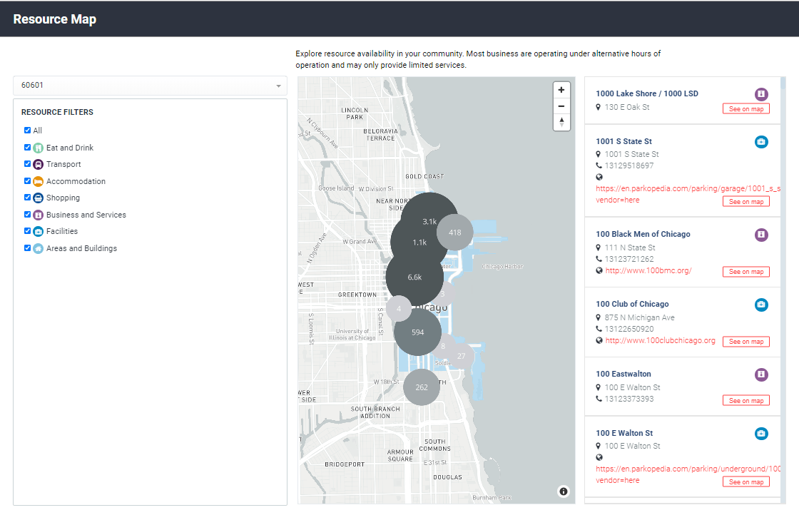
CHICAGO – City Tech Collaborative has launched a new resource webpage on the Chicago Health Atlas to help community partners, health care providers, researchers, and the general public understand COVID-19’s impact on local neighborhoods and find related resources. Building on the Chicago Health Atlas’ existing resources, the new COVID-19 page includes links to the latest COVID-19 data and testing locations, data on underlying conditions tied to the virus, and a map of essential businesses by zip code using HERE Technologies data. Visit the page at www.ChicagoHealthAtlas.org.

The Chicago Health Atlas is a health data resource including information on Chicago’s 77 community areas and over 160 health and demographic indicators including healthcare services, safety, income, and illness and death rates. The Atlas equips communities with open data and street-level resource maps that can be compared over time and across communities to drive future actions. Data on the Chicago Health Atlas is provided by over 30 sources including the Chicago Department of Public Health, MAPSCorps, and the Sinai Urban Health Institute.

Health organizations are racing to understand how health and wellness factors impact the spread and severity of COVID-19. With black Chicagoans dying from the coronavirus at a rate nearly six times greater than white residents, more data and research are needed to fully understand the pandemic and disparities that exacerbate health inequality. Open data from the Chicago Health Atlas serves as a resource to access and understand data that can be linked to COVID-19 trends and outcomes.

“The COVID-19 crisis highlights the need for data transparency and informed action,” said Dr. Wayne Giles, Chicago Health Atlas Advisory Member and Dean of the School of Public Health at the University of Illinois at Chicago. “Open data platforms like the Chicago Health Atlas put information directly in the hands of residents, healthcare providers, policymakers, and community organizations that can assess what’s happening and deliver local support where it’s needed most.”

The addition of HERE Technologies’ data expands the Chicago Health Atlas’ resources by 62,000 data points. Arranged by zip code, the map view shows the location and contact information for essential businesses operating during the COVID-19 pandemic, including banks, ATMs, grocery stores, food pantries, transportation options, and healthcare and government services. The COVID-19 page also links to the Atlas’ data on underlying conditions, the open application programming interface (API), COVID-19 funding resources and testing sites, and the latest COVID-19 data from the City of Chicago.

“Location data provides important context and benefit during public health emergencies,” said Adrian Novik, Senior Director of Global Content Product Management and Innovation at HERE Technologies. “We’re proud to contribute to the Health Atlas’ existing resources page localized data and information for the community to better understand what is accessible during this challenging time.”

Screenshot from the Chicago Health Atlas shows the new resource map resources for zip code 60601 that incorporates HERE Technologies’ data.

Data from the Chicago Health Atlas can help identify urgent, unmet needs in underserved communities.  In a COVID-19 Virtual Town Hall in April 2020, the Chicago Racial Equity Rapid Response Team used the Atlas’ open data to show how the South Shore community experiences higher rates of diabetes, hypertension, and asthma compared to the rest of the City. For example, 32% of South Shore residents have limited food access compared to 8.5% of Chicago residents overall. Groups such as the Racial Equity Rapid Response Team are responding to the disproportionate impact of the pandemic on African American communities and correlating underlying conditions and COVID-19 risks. City Tech offers training to organizations to utilize Chicago Health Atlas data in conjunction with their own work to inform additional research and programming responses.

The new COVID-19 data resources are part of City Tech’s broader response to the pandemic, including partner training on data visualization and analysis. City Tech’s Partnership Innovation Fund also provides direct funding to help Health Atlas partners prepare and add new datasets to the platform. The Chicago Health Atlas is part of City Tech’s Healthy Cities Initiative, which addresses physical, socioeconomic, and technological barriers to strong and vibrant communities. City Tech is also pursuing COVID-19 related work and collaborative solution development in advanced mobility, parking innovation, freight and logistics, and urban infrastructure. These solutions are helping address current issues while also positioning cities and partners to “bounce forward” in the wake of coronavirus and be better prepared for emerging needs and future crises.

To explore the Chicago Health Atlas and access the latest data, visit www.ChicagoHealthAtlas.org.

For more information about City Tech Collaborative, training on using the Chicago Health Atlas for your organization, or to add your own data to the resource, contact City Tech at Collaborate@CityTech.org.

Click here to download the press release (PDF).


About City Tech Collaborative (City Tech): City Tech is an urban solutions accelerator that tackles problems too big for any single sector or organization to solve alone. City Tech’s work uses IoT sensing networks, advanced analytics, and urban design to create scalable, market ready solutions. Current initiatives address advanced mobility, healthy cities, connected construction, and emerging growth opportunities. City Tech was born and raised in Chicago, and every city is a potential partner. Visit www.CityTech.org and follow us on Twitter and LinkedIn.

About the Chicago Health Atlas: The Chicago Health Atlas is a community health data resource that residents, community organizations, and public health stakeholders can easily search, analyze, and download neighborhood-level health data for the City of Chicago. A City Tech solution, the Chicago Health Atlas was initially developed in 2012 by the Smart Chicago Collaborative and the Chicago Department of Public Health (CDPH) with funding from the Otho S.A. Sprague Memorial Institute. Explore the Chicago Health Atlas by visiting www.ChicagoHealthAtlas.org.

About HERE Technologies: HERE, a location data and technology platform, moves people, businesses and cities forward by harnessing the power of location. By leveraging our open platform, we empower our customers to achieve better outcomes – from helping a city manage its infrastructure or a business optimize its assets to guiding drivers to their destination safely. To learn more about HERE, please visit www.here.com and http://360.here.com.

Member News: ParkMobile Data Shows a Slow and Steady Comeback in U.S. Cities

Parking transaction data from over 400 cities indicates that people are getting back on the roads

Atlanta, GA, – May 27, 2020 – ParkMobile, the leading provider of smart parking and mobility solutions, revealed new data today that shows increasing parking transactions in cities across the U.S. In early to mid-March, as fears of COVID-19 spread and more cases were diagnosed, cities and states shut down and people stayed at home. This caused a significant drop in the number of daily parking transactions in cities. The ParkMobile app is available in over 400 cities in the U.S., so the company’s data presents a clear view of the impact of the pandemic on consumer mobility.


Chart 1 in the infographic shows the severe drop in parking transactions as COVID-19 cases increased in March and states started to shut down. Compared to the previous month, parking transactions were down almost 95% across the country. This indicates that most non-essential workers were following the stay at home orders to help prevent spread of the virus.

Park Mobile Chart 1

In recent weeks, ParkMobile data reveals that activity is starting to gradually pick up. Cities and states are lifting some restrictions and parking transaction volume is slowly increasing on a week-to-week basis. This is a clear sign that people are going out more often. In Chart 2 in the infographic, you can see the week-over-week growth in parking volumes. It is still not clear from the data if and when things will get back to pre-COVID-19 levels.

Park Mobile Chart 2

The top 10 cities in the U.S. saw a slower rate of decline in early-to-mid March than smaller cities overall. Chart 3 in the infographic shows that the big cities hit their bottom about a week after the smaller markets. The rate of recovery for big cities has also been flatter than smaller cities because they did not initially decline as much.

park mobile chart 3

Beach communities are seeing the biggest increase in parking volume as people are looking for activities where they can be outdoors while social distancing. Chart 4 in the infographic shows that parking transactions in beach communities are outpacing those in cities. As summer approaches and the weather gets warmer, beach parking transactions should continue to increase. ParkMobile recently introduced service to the Borough of Belmar at the Jersey Shore. According to Belmar Mayor Mark Walsifer, “The Borough of Belmar wants to ensure the safety of visitors and residents. By partnering with ParkMobile to offer contactless parking payments, we are working to provide our community with a smart mobility option for anyone looking to spend time at the beach.”

park mobile chart 4

While parking volumes are picking up across the country, the way people are paying for parking is also changing. Cities are actively promoting contactless payments through apps like ParkMobile in an effort to stop people from touching the meters. Many cities are reporting that utilization of the app versus the meter has shifted heavily towards the app over the past three months. One large city reported that utilization of the app versus the meter jumped from 60% up to 80%.

In a recent move, New York City Department of Transportation launched the ParkMobile app in addition to the current ParkNYC app, also powered by ParkMobile, to give people more mobile payment options in the city. According to a recent statement from NYC DOT Commissioner Polly Trottenberg, “DOT is asking all New Yorkers who can to switch to Pay-By-Cell, which will reduce the need for physical cash transactions at our 14,000 parking meters. Contactless Pay-By-Cell reduces exposure risk for the public and our workforce. Please help us reduce the need to physically service parking meters and collect, sanitize, and securely store cash during this crisis.”

“It’s very clear that one of the lasting impacts of COVID-19 will be that people want more contactless payment options,” says Jon Ziglar, CEO of ParkMobile. “We’re proud that we can partner with cities to promote use of the app in order to keep people safe and protect city workers.”

ParkMobile continues to encourage people to do everything they can to prevent the spread of the virus including wearing masks, washing hands, and social distancing. The company’s headquarters in Atlanta, GA, has been closed since March 12th, and all 200 employees have been working from home since that time. The company hopes to reopen in the near future but will only do so when it is safe for employees to return.

View the full report here.


About ParkMobile 

ParkMobile, LLC is the leading provider of smart parking and mobility solutions in North America, helping millions of people easily find, reserve, and pay for parking on their mobile device. The company’s technology is used in thousands of locations across the country, including 7 of the top 10 cities as well as college campuses, airports, and stadiums. People can use ParkMobile solutions to quickly pay for on-street and off-street parking without having to use a meter or kiosk. Additionally, ParkMobile offers parking reservations at stadium venues for concerts and sporting events. Reservations are also available in metro area garages, allowing people to drive into the city without having to worry about finding parking. ParkMobile has been named to the Inc. 5000, Deloitte Fast 500, Smart Cities Connect “Smart 50,” and the Atlanta Journal Constitution’s Top Workplaces. Additionally, the company won the 2019 Stevie Awards for Most Innovative Tech Company and Best Travel App. For more information, visit ParkMobile.io or @ParkMobile on Twitter.


Learning from COVID-19: Connecting with the Research Community

COVID-19 Research and recovery
TRB/NAS

By Stephanie Dock, AICP, and Katherine Kortum, PhD, PE

This blog post is part of a special series on curb management and COVID-19. A joint effort of the International Parking & Mobility Institute, Transportation for America, and Institute of Transportation Engineer’s Complete Streets Council, this series strives to document the immediate curbside-related actions and responses to COVID-19, as well as create a knowledge base of strategies that communities can use to manage the curbside during future emergencies.

The research community is quickly engaging to help understand and evaluate responses to the COVID-19 pandemic. Practitioner and researcher collaboration will improve our understanding of what has worked and what has not, and how we might change our curbside in the longer term–whether for pandemic responses or for everyday operations in the coming “new normal.”

The Transportation Research Board (TRB) has coordinated and undertaken research for decades. While TRB’s completed research efforts are not specific to COVID-19, prior research is valuable for planning and responding now. Transportation in the Face of Communicable Disease details research on response strategies, transporting essential personnel, communicating clearly during a public health crisis, and more.

TRB launched its “Research Needs Statement Express” to rapidly capture the questions and research ideas generated by the COVID-19 pandemic. This call for submissions recognizes the need to engender collaboration faster than the typical formal process for developing research ideas. TRB is also partnering with the American Association of State Highway Officials (AASHTO), American Public Transportation Association (APTA), and others to develop and soon publish pandemic-related research needs for all transportation modes.

Finally, TRB is developing workshops to help determine questions (and some answers!) in specific areas. Summer 2020 will likely include a summit on scenario planning for transit and shared mobility during the COVID-19 recovery and in 2021, TRB and the European Commission will jointly hold a research summit on COVID-19 effects on transportation.

Academic researchers bring analytical approaches and resources municipal and private sector partners can look to complement their efforts, including:

  • Peer review network to collaborate and objectively vet research.
  • Student researchers (the next generation of transportation professionals), who bring energy and ideas.
  • Capacity to conduct objective, mutli-disciplinary research and analysis through course projects or faculty research.

Examples of academic research underway or projects supporting evaluation of mobility networks during this pandemic include:

Watch for more studies in TRB’s Research in Progress database. For ideas on who to contact for collaboration, start with USDOT’s directory of University Transportation Centers.

Strong partnerships among municipalities, the private sector, and academia are key to offering support and transformative solutions in our pandemic response.

Stephanie Dock, AICP, manages the research program for the District Department of Transportation in Washington, D.C.

Katherine Kortum, PhD, PE, is a senior program officer at the Transportation Research Board in Washington, D.C.


A Discussion About Curb Management

By Benito Pérez

IPMI Blog 031920

Not since the 1930s has curbside management (formerly known as on-street parking) received so much attention among the transportation industry (and the public!). With cities far and wide densifying and becoming the centers of population activity, city transportation officials are looking at ways to optimize not only multi-modal mobility (via increased diverse transportation investments), but also multi-modal accessibility. Regardless of mode, both people and goods meet on the city’s curb. Left unchecked, cities face ramifications from the obvious (congestion, safety implications) to the abstract (vulnerabilities to climate change, health expectancies). It becomes imperative for municipalities, large and small, to come to terms with the need for multi-modal curbside management.

However, what is curbside management? Depending on the perspective, the term can have varying definitions. Common between them is that curbside management involves the nexus point between the roadway and the pedestrian realm. It is in this space where people and goods transact. In older cities, regulations were enacted to manage horses and carriage access and the maintenance of that nexus space (see Washington, D.C.’s Parking Acts from the late 19th century). In the early 20th century after the advent of the automobile, technology innovation to manage the curbside led to the advent of the parking meter in 1935 and its subsequent proliferation in cities far and wide since then.

Today, technology disruptions in mobility have led to the rise of transportation network companies, connected/autonomous vehicles, expansion of mass transportation services, and on-demand delivery (as a result of on-line commerce). Because of this disruption paired with densifying cities, the curbside demand has diversified and intensified. Gone are the days of facilitating the curb for vehicle storage. Today is the day to facilitate the optimization of people and goods movement.

The IPMI Research & Innovation Task Force is offering a blog post series to help demystify the approach to implementing curb lane management strategies for the industry. The blog series will present a common model for implementing curb management:

  • Measure
  • Manage
  • Monitor
  • Optimize


Benito Pérez is curbside management operations planning manager at the District Department of Transportation, Washington, D.C., and a member of IPMI’s Research & Innovation Task Force.

Data-based Storytelling

Data-based storytellingBy L. Dennis Burns, CAPP

According to the National Association of City Transportation Officials (NACTO), shared micro-mobility devices like bikes and scooters provided more than 84 million trips across the U.S. in 2018. While these numbers are impressive and contribute to reductions in urban area congestion and greenhouse gas emissions, I have been worried that the e-scooter industry in particular may be facing an uncertain future as it struggles with escalating accident rates and negative headlines.

I recently read an article entitled: “Micro-Mobility Contest Wants to Spark Data-Based Storytelling.” In this article, e-scooter operator Spin is leading a project in partnership with data firms StreetLight Data and Populus to make troves of micro-mobility data available to nonprofits advocating for safer streets.

According to the article, “Advocates working for improved bike, pedestrian, or other micro-mobility projects in cities across the U.S. could soon have access to new datasets, as they make their case to officials. Spin, an operator of e-scooters, is leading a pilot known as the Mobility Data for Safer Streets (MDSS) which asks nonprofits and other micro-mobility advocacy groups to apply for one of up to five slots to participate in the program. The five winning organizations will have access to a year’s worth of mobility data collected by StreetLight Data and Populus, two leading data collection and analysis firms often used by cities, transportation agencies, and others looking to use traffic and other data to shape transportation policy.”

I am encouraged by this move to better use available data in advocacy for safer streets as cities and states work to shape the public policy to both regulate the devices and reshape the public streetscape to accommodate them. It will be interesting to see what comes from this initiative.

L. Dennis Burns, CAPP, is regional vice president, senior practice builder, with Kimley-Horn.

Researchers Investigate How Passengers Feel About Autonomous Vehicles

How would you react as a passenger in a self-driving car? Would your hands sweat? Heart race? Would your muscles tense? Or would you sit back and relax as the automakers advise? A group of researchers wants to find out.

University of Waterloo experts are recruiting volunteers to go for rides in autonomous vehicles so they can measure signs of anxiety and stress as the car drives in different ways. The car is programmed to drive with different levels of aggression while passengers, who are asked to watch a video, are monitored for signs of distraction and stress. So far, researchers say people get less anxious the more rides they take, and they hope their research will pave the way for cars to react to their passengers’ anxiety and adjust driving accordingly.

Read the whole story here.